
Queenstown, la segunda ciudad más
poblada de Otago (<15000 habitantes) después de Dunedin, se encuentra
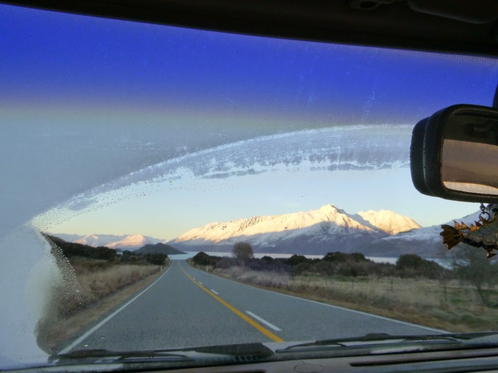
únicamente a 45 km de Glenorchy. Ambas poblaciones se encuentran unidas por la
Glenorchy Road, considerada por la Humanidad entera como una de las carreteras
más bonitas del Mundo.
A Queenstown vamos a cenar de vez
en cuando con Joan i Èlia, vamos a nadar a la piscina de Frankton y vamos,
sobre todo, a hacer la compra cada dos o tres semanas. Es nuestra metrópolis
aquí en los Alpes neozelandeses.

Gran parte del día Queenstown
está a la sombra de una montaña de 1748 metros, el Ben Lomond. ¿Subimos?

Después de dos días de intensas
nevadas por todo el sur de Nueva Zelanda (eso nos incluye) tuvo lugar una feliz
coincidencia: día soleado con día de descanso para Marina, Joan, Èlia y yo. A
la expedición se unió Laia, recién llegada desde Gavà con la intención de estar
por aquí un mesecito. Nueva Zelanda le dio una buena bienvenida.

Para ascender al Ben Lomond
primero hay que subir al Montjuïc de Queenstown, popularmente conocido como la
Góndola porque tiene un teleférico al que aquí se refieren como góndola.

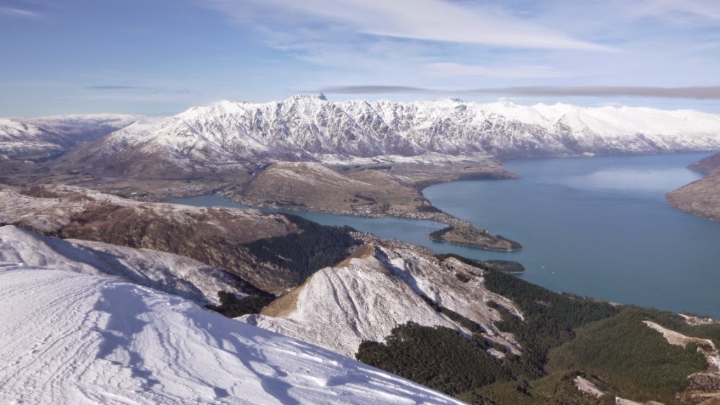
El camino hasta la cima es a
través de un bosque de pinos malignos (especie invasora) por el que transcurren
circuitos de descenso para bicicletas que se cruzan constantemente con el
camino para peatones reacios a pagar treinta dólares por utilizar el telehuevo.
Caminando se tardan unos tres cuartos de hora en llegar hasta arriba. Desde la
cima de la Góndola se disfrutan unas de las mejores vistas de la bahía de
Queenstown.

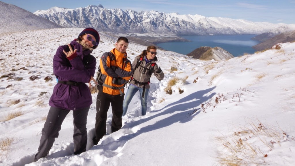
Una vez hechas las decenas de
fotos de rigor nos dimos la vuelta y nos dirigimos hacia el objetivo del día,
que es la montaña que se ve detrás de Marina en la foto superior. El Pedraforca
de Nueva Zelanda.


Salimos del bosque de pinos
invasores diabólicos y caminamos por la ladera de la Góndola durante un buen
rato sintiendo de vez en cuando un fuerte olor a Orco de Mordor. Eran cabras
montesas que no han conocido una ducha en su vida pero teníamos tanto frío que
no quisimos pararnos a hacerles un fotolibro.


Afortunadamente nuestro camino se
cruzó con el del Sol (estaríamos juntos hasta el descenso) por lo que pudimos
pararnos de vez en cuando a mirar el paisaje que íbamos dejando atrás: el lago
Wakatipu y los Alpes recién nevados.
La verdad es que el avance se
hacía bastante complicado por momentos ya que no podíamos dar dos pasos seguidos
sin sentir la necesidad de pararnos a hacer fotos. ¡Así no hay quien suba
montañas! Pero es que claro, imaginaos que en una de estas ocasiones no nos
paramos pensando que el paisaje seguirá estando ahí todo el día y luego resulta
que se pone a diluviar. Porque hay que tener presente que en la montaña el
tiempo puede cambiar increíblemente rápido.


Y de este modo fuimos avanzando
hasta que llegamos al cuello en el que a la derecha teníamos el Mount Bowen y a
la izquierda el Ben Lomond.

En este momento nos paramos
porque, la foto superior es buena prueba de ello, había que mentalizarse para
subir. Porque el camino se las traía.


Afortunadamente en el
Departamento de Conservación son conscientes de la labor de mentalización que
uno tiene que llevar a cabo antes de subir así que han puesto un banco para que
por lo menos puedas hacerla sentado. Este debe ser uno de los mejores bancos
del Mundo. Es sorprendente que Matías Prats no lo anuncie.

Así que con la certeza de que las
vistas desde la cima del Ben Lomond debían ser espectaculares nos encaminamos
hacia allá, con paso firme, lento pero seguro. Esencialmente lento. Lo vamos a
dejar en decidido.


Había mucha nieve, constantemente
a la altura de los gemelos y en ocasiones hasta la cintura, pero no nos
rendimos. Mantuvimos nuestro ritmo machacón serpenteando por la falda de la
montaña.


Una buena parte del camino de
aproximación se hace por lo que sería la cresta de la montaña por lo que si
mirábamos hacia la derecha veíamos un mar infinito de montañas nevadas y si
mirábamos hacia la izquierda veíamos las famosas Remarkables y el lago
Wakatipu.


Si mirábamos hacia delante lo
veíamos todo blanco porque la subida era muy empinada, tanto que casi tocábamos
la nieve con la nariz al avanzar.


Y conseguimos llegar a la cima
donde hacía un viento endiablado y un frío del carajo, además de un Sol
estupendo que nos permitió disfrutar de unas vistas increíbles durante un par
de minutos, porque ahí no había quien se tomase las croquetas y los buñuelos de
bacalao que llevábamos en la mochila.


Sí, llevábamos croquetas y
buñuelos de bacalao porque Marina colaboró en la reunión anual de la asociación
“Rural Women of New Zealand” confeccionando un delicioso y completísimo menú “Spanish
Feast” de comida típica de casa que ya explicaremos con más detalle más
adelante.
Enrique & Marina
TRAMPING AROUND QUEENSTOWN: BEN LOMOND TRACK
Queenstown is the second largest city in Otago
(with over 15000 people) after Dunedin and it is only 45 km far from where we
live in Glenorchy. These two places are connected by the Glenorchy Road, which
is considered one of the most beautiful drives in the World.
We sometimes go to Queenstown to have dinner
with Joan and Elia, to swim in the Frankton swimming pool but, overall, we go
grocery shopping every two or three weeks. Queenstown is the little metropolis of
the Southern Alps.
The city is most of the day on the shade of a
1748m high mountain called Ben Lomond. Shall we climb it?
After two days of heavy snowing in the South of
New Zealand (this obviously includes us) a happy coincidence took place:
stunning sunny day, day off for Enrique, Joan, Elia and myself. Laia, a new
arrival from Catalonia who will spend a month exploring the country, joined the
expedition and New Zealand welcomed her in a pretty good way!
To get to Ben Lomond we first had to walk up to
the Gondola which is the quintessential scenic lookout of the city and you can
reach using the aerial cable-car or gondola.
The walk up to the lookout runs through a pine
forest (a foreign three as we have said in previous posts) and crosses a
network of downhill-mountain-bike tracks. Thus pedestrians should be aware of
the riders when crossing their lanes, as these guys go down really fast. The
ticket for the gondola costs thirty dollars up and down and from the top you
can enjoy the best views of the Queenstown bay you can see from the city.
Besides the views there is a café, a restaurant and a luge circuit.
After taking dozens of pictures from the
viewing deck, we turned our backs to the nice sights and kept going to the
mountain target of the day which is the peak behind me in the picture above.
We got out of the pine forest and walked on the
shady hillside of the mountain where the Gondola is. Sometimes we felt a strong
smell of Mordor orc. That wasn’t orcs but filthy wild goats but we were getting
cold walking in the shade so we didn’t stop to make a photobook of them.
Luckily, the Sun came to lighten our way and stayed
with us most of the track making our photo stops more pleasant. Then, we could
take pictures not only of the sight we had in front but also of the views we
left at our backs, this is the lake Wakatipu and the Southern Alps covered in
fresh snow.
However, walking forward became more challenging
every minute as it was very difficult to step ahead and beat the temptation to
stop again to take more pictures. This is not a serious way to climb peaks!
But, you have to understand, if we don’t stop thinking that this view will be
there forever I’m sure the next minute it’ll start raining (or snowing) so we
not only would miss the pictures but also we’d have to abort the expedition. As
responsible half-kiwis, we always keep in mind that weather conditions may
change any time in the mountains.
So, in this way we got to the saddle that breaks
the track in two: right towards Mount Bowen and left to Ben Lomond.
Here we definitively had to stop because, as
you can see in the picture at the top, we had to get our minds ready to start walking
the track.
We want to publicly acknowledge the kindness of
the Department of Conservation that, aware of this need of trampers to get
themselves ready, has installed a wonderful bench to do so while sitting down. This
might be in the top ten of Best Benches of the World list, if there’s such
thing.
After that and with the feeling that the views
from the top will be worth the effort, we resumed our way steadily, slowly but
confidently. Particularly slowly, though.
There was a lot of snow, most of the time up to
our calves but sometimes up to our waists, but that wouldn’t make us give up.
We kept our confident although slow movement winding on the slope of the
mountain.
The last part of the track runs through the
ridge of the mountain providing the climber with spectacular views of both
sides of the mountain. Overlooking North, we saw a massive sea of snowy
mountains including Coronet Peak, Mount Dewar and the Moke Lake upper in the
climb; on the Southern side, the Remarkables and the Lake Wakatipu.
Looking ahead we could only see white because
the slope was very steep, so steep that our noses almost touched the snow while
moving forward.
But finally we got to the summit where the
extremely cold wind coming from Mordor almost blew our wigs. Fortunately, the
Sun was shining and we could enjoy the breathtaking views we’d been promised,
but only for two minutes as the summit wasn’t the place to sit down for the
picnic of croquetas and mackarel fritters we had in our backpacks.
We’re serious about having a picnic consisting
on these Spanish delicatessens. I helped the Rural Women Association of
Glenorchy thematize their annual assembly, so they had a complete and delicious
Spanish Feast after the meeting. But we’ll tell more about it some other time.
Enrique & Marina