
Con tal de aprovechar los últimos
coletazos indolentes de este verano austral tan inusualmente largo que estamos
teniendo nos hemos ido de parranda por la cuenca del río Scott, o lo que es lo
mismo, hemos hecho el Scott Creek Track. Así que, después de esta frase tan
quijotesca, empezamos la crónica como es debido.

Nos levantamos tarde y con una
pereza dantesca, miramos por la ventana y había unos nubarrones feos como
robarle un caramelo a un niño justo encima de las montañas a las que queríamos
ir (robar es feo en general, ya sea encima de una montaña o en otro lado, las
nubes eran de tormenta, ellas eran las feas). Pensamos en tomarnos el día libre
de diversión y ejercicio y dedicarnos en cuerpo y alma a no dar palo al agua
como buenos hippies viajeros (lo de viajeros lo tenemos un poco aplazado, pero
volveremos al camino).

Los que nos conozcáis sabréis que
yo era el que pensaba todo esto mientras que por la cabeza de Marina circulaban
otras historias hiperactivistas completamente opuestas… “Vamos a subir a esa
montaña y si tenemos tiempo a esa otra también que no es tan alta, luego vamos
a comer en ese valle que es muy pintoresco, vamos a volver al coche en la mitad
de tiempo del que nos ha costado subir y sin rompernos ningún hueso, vamos a
volver a casa, recoger la colada que lleva tendida ya casi un día, regar el
huerto y hacer sopa de calabacín que tengo el caldo de pollo de la cena del
otro día descongelándose y luego voy a hacer los deberes del curso de pobreza
global que estoy haciendo por internet”. Y esto lo piensa mientras se lava los
dientes, prepara gachas de avena para desayunar, se ducha y prepara la mochila
para la excursión. No necesariamente en este orden. Mientras tanto yo he
conseguido, con suerte, decidir si quiero ocho tostadas o hago un exceso y me
como diez. Misteriosamente el primero en lograr estar listo para partir soy yo.
¡Victoria!

El apartadero donde se deja el
coche para empezar el camino está a tres canciones de Estopa de Glenorchy. Allí
dejamos el coche e inmediatamente se nos para un todoterreno detrás del que se
bajan dos perros y dos fornidos muchachotes con escopetas para elefantes.
Empezamos a caminar siguiendo el curso del río y los cazadores nos siguen.
Nosotros sabemos que el camino no es por ahí porque no hemos visto ningún
triángulo naranja del DOC, pero seguimos a ver si los cazadores nos avisan de
que vamos mal. No lo hacen así que nos damos la vuelta y volvemos a la casilla
de salida. Ahí pudimos ver un poste naranja de los que te alegras de ver cuando
estás a punto de aceptar, con el orgullo herido, que estás perdido.


La categoría del camino es
“tramping track” que básicamente quiere decir que te vas a pasar la excursión
buscando triangulitos naranjas. Nosotros hicimos un máster el día del Earnslaw
Burn y ya estamos acostumbrados así que nos fuimos montaña arriba con
confianza.

El primer tramo, de un par de
kilómetros, es a través de unos terrenos privados de hierba alta y pendiente
aguda donde hay tres postes naranjas más o menos equiespaciados por los que hay
que pasar si no quieres despeñarte, como en un videojuego de plataformas. Es un
terreno idóneo para que los velocirraptores se escondan y acechen a
excursionistas incautos. Afortunadamente se extinguieron hace millones de años.

Una vez salvada la “hierba alta,
plantas pegajosas, arbustos con pinchos y barro negro” el camino se adentra en
lo que se conoce como “beech forest” o el hayedo típico de la zona. Aquí es
donde empieza la angustiosa búsqueda de los triángulos. Nuestro sistema es
infalible: en el momento que pensamos que estamos a punto de perdernos uno de
los dos vuelve al último triángulo que hemos visto mientras que el otro busca
el siguiente en una dirección que sospechamos es la correcta. Si no lo
encuentra en cinco minutos vuelve y el que estaba esperando en el triángulo
sale a buscar en otra dirección.

De momento nos ha funcionado
siempre. Otro truco es buscar los triángulos de vuelta, lo que nos permite
tener el centro de control de tráfico un poco más adelante en la mayoría de los
casos. En caso de que pensemos que las señales están demasiado espaciadas
apilamos piedras a modo de hito o hacemos una marca en la corteza de un árbol
con la navaja de pescar en El Pueblo.

En fin que de triángulo en
triángulo llegamos hasta la Scott Basin, que literalmente se traduce como la
cuenca del río Scott, lo cual no tiene mucho sentido porque todo el camino
sigue el curso de río luego llevamos todo el rato en su cuenca. Hasta donde se
llega es hasta el cuenco que forman tres montañas en el que se juntan todos los
pequeños riachuelos y arroyos que forman el río Scott.


Allí decidimos dar el viaje de
ida por finalizado y tomarnos unas patatitas que llevábamos en la mochila. En
caso de tener energías y una tienda de campaña se puede seguir haciendo
“route”, que es como aquí denominan a los caminos no señalizados en absoluto,
subiendo a una de las montañas y bajando hasta el Kay Creek, desde donde se
puede llegar al valle Caples donde hay un sendero que lleva hasta la estación
ganadera de Greenstone. Se deben tardar unos tres días en hacer esto y se
necesita la confianza suficiente para hacer esta parte de ruta que nosotros, de
momento, no tenemos.


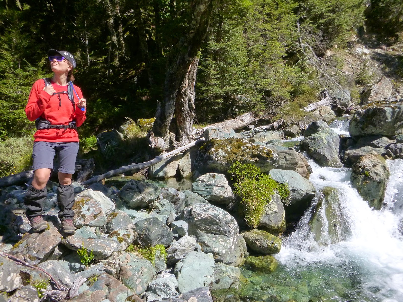
Descansamos un rato a la orilla
del río y nos volvimos para atrás. Más o menos a la media hora de empezar a
volver nos encontramos con los cazadores, que tenían pinta de no saber jugar a
los triangulitos. No les dijimos nada porque los perros parecían estar pasándoselo
en grande.

En el camino de vuelta nos hemos
caído un par de veces cada uno sin mayores consecuencias que llenarnos de barro
pútrido. La excursión ha merecido la pena y nos ha servido para coger fuerzas
para la próxima, que si todo va bien será de un par de días de duración
enlazando los valles Greenstone y Caples.
Enrique & Marina
English version
SCOTT CREEK TRACK

To make the most out of the last few days of this unusually long Austral
summer, we decided to go exploring around the Scott river by following the
Scott Creek Track in the Humboldt Range.

We woke up late and feeling pretty lazy, we looked out the window and a
thick layer of ugly clouds covered the peaks of the mountains where we wanted
to go. For a while we considered to take the day off of any fun and exercise
and devote our hearts and bodies to lounge around during the whole day and bake
cookies at the most.

Those who know us better may be guessing that it was actually Enrique
considering to not to do anything while in my mind tons of hyperactive options
appeared at the speed of light: “Let’s go up that mountain and to that other one as well if we have time;
then have a picnic in that other cute little valley; after we should go down
back to the car in half the time we went up and get back home; take the washing
down from the lines and fold it; water the garden and pick some zucchinis to
make soup for tonight, I already took the homemade chicken stock out of the
freezer and after dinner I’ll finish my on-line course homework while you
read those interviews you like from that on-line magazine”. As per Enrique, I think about all this while I brush my teeth, have a
shower, prepare my porridge and the picnic and the backpack for the day. Not
particularly following this order, though. In the meantime, hopefully he’d have decided whether he’ll be having eight
toasts or treat himself and have ten. Thus, he’s always ready to go
before I am.

The tiny carpark for that track is about three rumba songs far from
Glenorchy DF. Three seconds after turning the engine of the car off, a tough
4WD truck parked 5 centimetres behind us produced a couple of hunting dogs and
two blokes armed with two elephant size rifles.We started walking following the
river valley with the hunters behind us. However, we suspected that we were on
the wrong track (actually the wrong no-track) because we couldn’t find any DOC marks at all. Despite knowing it, we decided to go ahead
and see if those guys would show us the right way. They didn’t so after a few minutes we turned around and went back to the start
point. This is when we saw a wooden post with those orange tops that make your
day by telling you “hey! you’re not lost”.

This one is classified as a “tramping track” which basically means that the ways is not
particularly obvious and you should keep looking for route marks (usually
orange triangles or posts in the case of DOC maintained tracks) or just make
your own way from post to post. We’ve become pretty good at
finding routes, deciding ways from one sign to the next and finding our way
back to the track after getting (slightly) lost.

The first two kilometres cross some private owned land covered with
overgrown grass and steep slopes where there are only three orange wooden posts
more or less equally spaced which give you an idea about the direction you
should follow. The terrain is uneven and the ground densely hidden under the
vegetation so it’s difficult to see where you’re actually stepping on, walking there was a bit little those arcade
video games.

Once sorted the overgrown grass, the sticky plants, the prickly bushes
and the black treacly mud, the path enters the native beech forest. There is
where the annoying search for orange triangles really started. For this matter,
we’ve developed an unfailing system to not get
lost (at least to find the way after getting lost): when we can’t see where we’re going, one of us goes back to the last
orange triangle and searches a new one in whatever direction we think is right.
In the meantime the other one stays where he or she, still looking for a new
clue but not moving much.

So far, it has always work, we’ve always come back.
Another trick is using the marks pointing the way back to get a hint about the
direction to follow. Also, in some cases we don’t feel too comfortable
about finding the way back in a particular section, then we stack a few rocks
to build a little milestone in a clearly visible spot to serve as a guide on
our way back.

Anyway, somehow we managed to get to the Scott Basin, which seems to us
a bit of an odd name for it, as we’ve been all the time
walking by the basin of the creek. The end of the track gets you to the top of
a wide valley formed by three mountains of the Humbolt range in which all the
little creeks and streams meet and form the Scott creek.


We decided to leave the walking there and have the little snack we
carried on our backpack. However, if we had had the energy and a tent we would
have kept ahead on a route that goes up one of those mountains, then down to
the Kay Creek and from there to the Caples track which ends in the Greenstone
Station. That route takes about three days and requires certain knowledge of
the area, maps, some gear and confidence that we do not have so far.


Since we know our limits, we had a nice rest next to the river while
enjoying the nice scenery and turn back home. About thirty minutes after
turning back we met the hunters again, who seemed like they didn’t know to play the orange triangles game. We did not say anything to
them as they looked like they were having a lot of fun and knew what they were
doing.

On our way back we felt down a couple of times (each) with no major
consequence than covering ourselves in stinking putrid mud. The day out was
well worth the effort and was a good training for the next tramping challenge
which will be crossing along the Caples river valley and then link with to the
Greenstone valley.
Enrique & Marina
Molt bé! Desde Charrolandia un beso muy fuerte y agradecimientos por no haber esperado al doblaje en inglés (aquí no son bilingües)
ResponderEliminarEAR
Por fin. Todo el mes de marzo sin escribir, pensábamos que ya os habíais cansado. Besos
ResponderEliminarYo he ido escribiendo durante marzo, de hecho hay 5 entradas pendientes de traducción: tenemos 4 excursiones y el submarinismo en Milford Sound en el horno. Ya veremos cuando las vamos poniendo por eso jaja Besos
EliminarHabéis pensado en cambiar el nombre del blog a: "Vida de Marina y Enrique"? Porque de viaje ya no tiene nada!!! jajaa. Un saludo desde la UPC :)
ResponderEliminarBueno Vicente, el primer valiente en decírnoslo. Te voy a reconocer que lo de viaje está algo aparcado, pero la idea de volver a la mochila la tenemos latente. Consideraremos tu propuesta. Un abrazo bien fuerte!
Eliminar