sábado, 18 de abril de 2015

SENDERISMO EN EL REES VALLEY: KEA BASIN

Click here to read the English version


Hace unos días se alinearon los planetas del sistema solar y coincidimos con Jess, nuestra cocinera favorita y compañera de casa, en un día libre. Con un par de mentirijillas la convencimos para que nos acompañara a hacer una excursión de las largas por el Rees Valley, a tiro de piedra de Glenorchy y hasta ahora prácticamente inexplorado por nosotros.


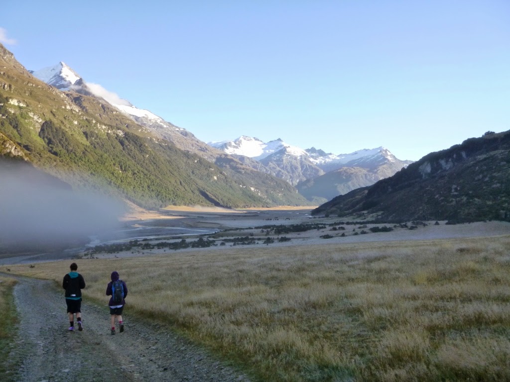
Empezamos a caminar muy pronto por la mañana ya que sabíamos (Jess no, esta era una de las mentirijillas) que nuestro destino quedaba lejos. El valle todavía se estaba desperezando cuando empezamos a recorrerlo siguiendo el curso del río Rees.


El Sol comenzaba a alzarse tras las montañas y el rocío de la mañana se evaporaba en masa con su calor. La neblina generada se levantaba lentamente creando una cortina de frío vapor que daba al valle un aire bucólico y pastoril. Como si fuésemos los pastores del pesebre de Navidad.


Las indicaciones que debíamos seguir estaban bien claras: caminar por el valle hasta pasar las cataratas Lennox y girar a la izquierda para entonces subir hacia el Kea Basin, en un camino marcado con palos y triángulos naranjas. Todo esto debía llevarnos algo menos de diez horas. Chupado.


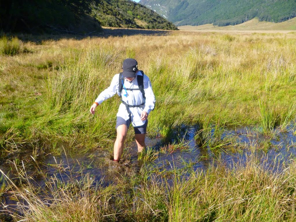
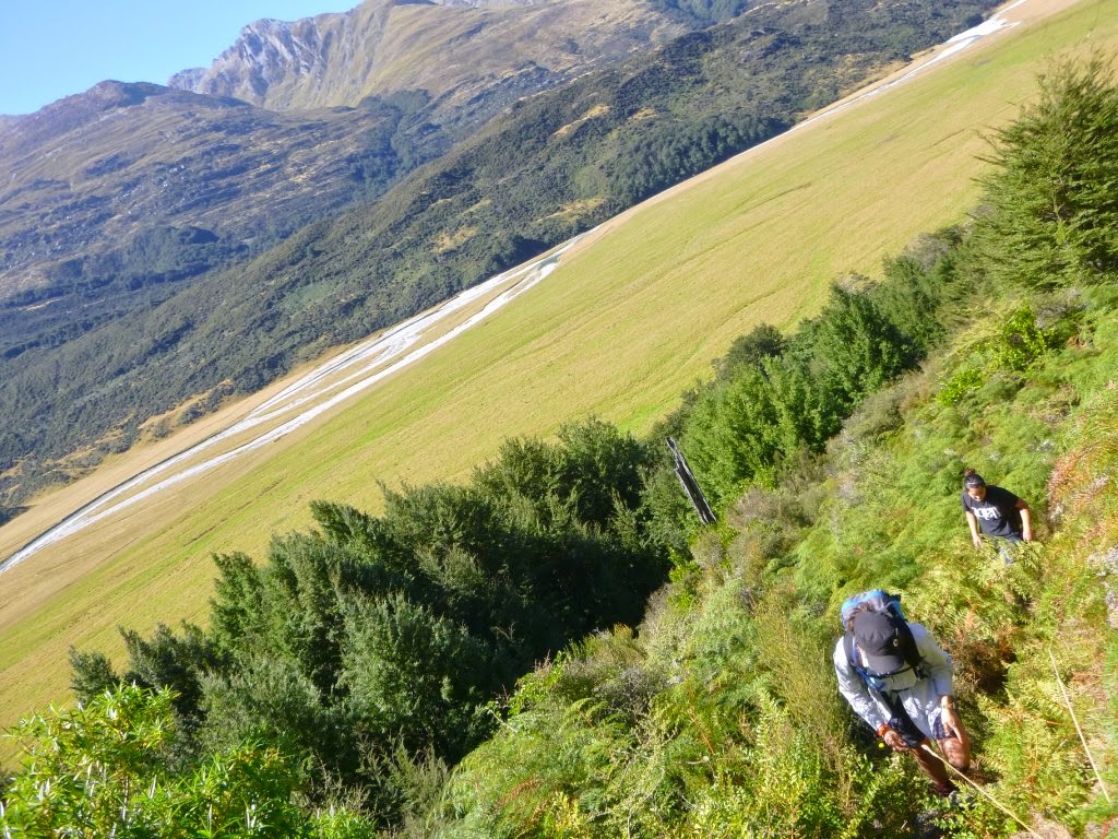
Encontramos palos marcadores desde el principio del camino así que los fuimos siguiendo. El recorrido nos llevaba por la derecha del valle, a través de un terreno terriblemente fangoso habitado por vacas diabólicas que nos miraban con hambre.


Tres horas después de empezar la agonía nos dimos cuenta de que al otro lado del valle había unas cataratas enormes. Entre ellas y nosotros un par de quilómetros de fango, vacas y cursos fluviales de agua helada. Decidimos seguir por nuestro camino marcado con la esperanza, ilusos, de encontrar unos puentecitos que nos llevasen hasta el comienzo de la ascensión al Kea Basin (Mount Earnslaw).


Pasado un rato nos dimos cuenta de que estábamos haciendo el tonto siguiendo por el lado del valle en que estábamos así que nos paramos, pusimos los brazos en jarras e hicimos ver que tomábamos decisiones. Afortunadamente en ese momento hizo su aparición, a lo lejos, un todoterreno que bajaba volando por el centro del valle. Ahí lo vimos claro, cruzamos todos los riachuelos y barrizales que se nos pusieron por delante y llegamos al “camino” que estaba usando el coche.


Una vez llegó a nuestra altura paró. Le dijimos al conductor que estábamos intentando ir al Kea Basin. ¿Lleváis un mapa? La primera en la frente. Afortunadamente los planetas seguían alineados y justo habíamos decidido cruzar el valle por donde debíamos, así que sólo nos quedaba saltar un par de alambradas electrificadas para llegar al inicio del camino de ascenso. Qué suertudos.


La ascensión no tuvo mucha historia, típico camino de bosque neozelandés, empinado y con curvas.


Pasados tres cuartos de hora llegamos al refugio para los valientes que deciden intentar la ascensión al Mount Earnslaw, que estaba bastante guarrete y no tenía vistas, así que lo ignoramos y seguimos caminando.


Y por fin llegamos arriba, justo donde los montañeros se paran a tomar el bocata y resoplar antes de ascender, o no, a la cima de la montaña más alta de la zona. Parte de las nieves del Earnslaw se deshielan por esta ladera, generando un par de riachuelos que bajan a modo de cascadas hasta el Kea Basin, desde donde se puede ver la práctica totalidad del Rees Valley.


Ya de vuelta decidimos que no queríamos volver a pasar por los inacabables barrizales del otro lado del valle, así que decidimos seguir lo que parecía la pista por la que había ido el todoterreno.


Tuvimos que cruzar el río Rees un mínimo de diez veces hasta llegar a dónde habíamos dejado el coche, pero mereció la pena cambiar el barro putrefacto por las aguas heladas.


Al llegar a Glenorchy, a modo de premio, fuimos a la cafetería del pueblo y nos tomamos unos batidos de chocolate con helado y unas pizzas hechas en horno de leña. No sabemos si Jess querrá volver a ir de excursión con nosotros.

Enrique & Marina
English version

TRAMPING AROUND THE REES VALLEY: KEA BASIN


A few days ago the planets were aligned and we had a day off with Jess, our favourite girl-chef and house mate. We tricked her a bit to persuade her to come with us for a good hike through the Rees Valley, very close to Glenorchy and still unexplored for us.


We started fairly early in the morning because we knew (well, to be honest Jess didnt) the destination was far. Then, the valley was still asleep when we started walking across the meadows of the Rees river.


The Sun was raising behind the mountains and the morning dew was slowly evaporating with its heat. The thin mist covering the valley was disappearing leaving behind a bucolic and pastoral landscape. And there, in the middle, the three of us looked like the three wise men at my mums Nativity.


This time the directions were very clear: walk along the valley up to the Lennox waterfalls and then take the track on the left to the Kea Basin which should be marked with the usual orange DOC signs. And that should take us less than ten hours. Easy.


We found track posts from the very beginning of the path, so we followed them. The way went by the true left of the river (our right), through a terribly muddy ground where evil cows grazed and looked at us with hungry eyes.


About three hours latter we noticed that on the other side of the valley, on the right of the river, there was a huge waterfall, the Lennox. Between us and them there were about a couple of ks, treacly brown mud and an ice cold river. We decided to stick to the sing posts with the hope of finding some sort of bridge system that would take us to the other side and the true start to the Kea Basin (Mt Earnslaw).


After a little bit we realised that we were just being fools by simply following the valley (thats the Rees Valley track) hoping to find some indications to the Kea Basin while knowing that we had to start the climb on the left of those waterfalls. That was the time to stop, put our hands on our hips and pretend we were thinking and taking state-level-importance decisions. Luckily, at the same time, a real 4WD was making its way down the centre of the valley crossing meadows, sand banks and rocks. That looked like a signal, we crossed the river too to get to the path that the truck was driving.


When close enough, we asked them to stop. Hi there-we said to the driver-were struggling to find the Kea Basin track start. Do you guys have a map?-he said. Boom! In our face, we didnt have a map. However, we were lucky again and we were just in front of the start of the climb. That guy only had to point where the DOC screen and the first big orange triangle were. After jumping a couple of electric fences we were ready to start going up the mountain. That was a really lucky move after all.


The climb itself didnt have much interest: typical native beech forest, steep and windy.


After about 45 minutes going up we saw a hut mostly used to spend the night before attempting Mt Earnslaw. The hut is pretty rough, doesnt have any interesting views and looked a bit neglected, therefore we ignored it and kept walking.


Finally we reached the basin, where Im sure the mountaineers have a snack and a deep breath before starting the serious tramp up to Mt Earnslaw, the highest mountain in the head of the lake. The mountains snow partially melts and drips down this slope creating a few streams that pour the water down to the Kea Basin where we could overview almost the entire Rees Valley.


On the way back we choose not to follow the orange posts and skip the mud puddles. Instead we decided to follow what we though was the 4WD track.


That took us to cross the Rees about ten times before we could reach the Muddy Creek carpark, where we left the car. Nevertheless, we dont regret changing rotten smelly mud for clear but icy water.


Later that day and back in Glenorchy, we treat ourselves going to the village cafe where we ordered three iced chocolates and three huge pizzas cooked in a wood fired oven. I had to ask for half of my pizza to take away. We dont know if Jess would like to come to the mountain with us again. We hope so, though.

Enrique & Marina

jueves, 2 de abril de 2015

SCOTT CREEK TRACK

Click here to read the English version


Con tal de aprovechar los últimos coletazos indolentes de este verano austral tan inusualmente largo que estamos teniendo nos hemos ido de parranda por la cuenca del río Scott, o lo que es lo mismo, hemos hecho el Scott Creek Track. Así que, después de esta frase tan quijotesca, empezamos la crónica como es debido.


Nos levantamos tarde y con una pereza dantesca, miramos por la ventana y había unos nubarrones feos como robarle un caramelo a un niño justo encima de las montañas a las que queríamos ir (robar es feo en general, ya sea encima de una montaña o en otro lado, las nubes eran de tormenta, ellas eran las feas). Pensamos en tomarnos el día libre de diversión y ejercicio y dedicarnos en cuerpo y alma a no dar palo al agua como buenos hippies viajeros (lo de viajeros lo tenemos un poco aplazado, pero volveremos al camino).


Los que nos conozcáis sabréis que yo era el que pensaba todo esto mientras que por la cabeza de Marina circulaban otras historias hiperactivistas completamente opuestas… “Vamos a subir a esa montaña y si tenemos tiempo a esa otra también que no es tan alta, luego vamos a comer en ese valle que es muy pintoresco, vamos a volver al coche en la mitad de tiempo del que nos ha costado subir y sin rompernos ningún hueso, vamos a volver a casa, recoger la colada que lleva tendida ya casi un día, regar el huerto y hacer sopa de calabacín que tengo el caldo de pollo de la cena del otro día descongelándose y luego voy a hacer los deberes del curso de pobreza global que estoy haciendo por internet”. Y esto lo piensa mientras se lava los dientes, prepara gachas de avena para desayunar, se ducha y prepara la mochila para la excursión. No necesariamente en este orden. Mientras tanto yo he conseguido, con suerte, decidir si quiero ocho tostadas o hago un exceso y me como diez. Misteriosamente el primero en lograr estar listo para partir soy yo. ¡Victoria!


El apartadero donde se deja el coche para empezar el camino está a tres canciones de Estopa de Glenorchy. Allí dejamos el coche e inmediatamente se nos para un todoterreno detrás del que se bajan dos perros y dos fornidos muchachotes con escopetas para elefantes. Empezamos a caminar siguiendo el curso del río y los cazadores nos siguen. Nosotros sabemos que el camino no es por ahí porque no hemos visto ningún triángulo naranja del DOC, pero seguimos a ver si los cazadores nos avisan de que vamos mal. No lo hacen así que nos damos la vuelta y volvemos a la casilla de salida. Ahí pudimos ver un poste naranja de los que te alegras de ver cuando estás a punto de aceptar, con el orgullo herido, que estás perdido.


La categoría del camino es “tramping track” que básicamente quiere decir que te vas a pasar la excursión buscando triangulitos naranjas. Nosotros hicimos un máster el día del Earnslaw Burn y ya estamos acostumbrados así que nos fuimos montaña arriba con confianza.


El primer tramo, de un par de kilómetros, es a través de unos terrenos privados de hierba alta y pendiente aguda donde hay tres postes naranjas más o menos equiespaciados por los que hay que pasar si no quieres despeñarte, como en un videojuego de plataformas. Es un terreno idóneo para que los velocirraptores se escondan y acechen a excursionistas incautos. Afortunadamente se extinguieron hace millones de años.


Una vez salvada la “hierba alta, plantas pegajosas, arbustos con pinchos y barro negro” el camino se adentra en lo que se conoce como “beech forest” o el hayedo típico de la zona. Aquí es donde empieza la angustiosa búsqueda de los triángulos. Nuestro sistema es infalible: en el momento que pensamos que estamos a punto de perdernos uno de los dos vuelve al último triángulo que hemos visto mientras que el otro busca el siguiente en una dirección que sospechamos es la correcta. Si no lo encuentra en cinco minutos vuelve y el que estaba esperando en el triángulo sale a buscar en otra dirección.


De momento nos ha funcionado siempre. Otro truco es buscar los triángulos de vuelta, lo que nos permite tener el centro de control de tráfico un poco más adelante en la mayoría de los casos. En caso de que pensemos que las señales están demasiado espaciadas apilamos piedras a modo de hito o hacemos una marca en la corteza de un árbol con la navaja de pescar en El Pueblo.


En fin que de triángulo en triángulo llegamos hasta la Scott Basin, que literalmente se traduce como la cuenca del río Scott, lo cual no tiene mucho sentido porque todo el camino sigue el curso de río luego llevamos todo el rato en su cuenca. Hasta donde se llega es hasta el cuenco que forman tres montañas en el que se juntan todos los pequeños riachuelos y arroyos que forman el río Scott.


Allí decidimos dar el viaje de ida por finalizado y tomarnos unas patatitas que llevábamos en la mochila. En caso de tener energías y una tienda de campaña se puede seguir haciendo “route”, que es como aquí denominan a los caminos no señalizados en absoluto, subiendo a una de las montañas y bajando hasta el Kay Creek, desde donde se puede llegar al valle Caples donde hay un sendero que lleva hasta la estación ganadera de Greenstone. Se deben tardar unos tres días en hacer esto y se necesita la confianza suficiente para hacer esta parte de ruta que nosotros, de momento, no tenemos.


Descansamos un rato a la orilla del río y nos volvimos para atrás. Más o menos a la media hora de empezar a volver nos encontramos con los cazadores, que tenían pinta de no saber jugar a los triangulitos. No les dijimos nada porque los perros parecían estar pasándoselo en grande.


En el camino de vuelta nos hemos caído un par de veces cada uno sin mayores consecuencias que llenarnos de barro pútrido. La excursión ha merecido la pena y nos ha servido para coger fuerzas para la próxima, que si todo va bien será de un par de días de duración enlazando los valles Greenstone y Caples.

Enrique & Marina


English version
SCOTT CREEK TRACK


To make the most out of the last few days of this unusually long Austral summer, we decided to go exploring around the Scott river by following the Scott Creek Track in the Humboldt Range.


We woke up late and feeling pretty lazy, we looked out the window and a thick layer of ugly clouds covered the peaks of the mountains where we wanted to go. For a while we considered to take the day off of any fun and exercise and devote our hearts and bodies to lounge around during the whole day and bake cookies at the most.


Those who know us better may be guessing that it was actually Enrique considering to not to do anything while in my mind tons of hyperactive options appeared at the speed of light: Lets go up that mountain and to that other one as well if we have time; then have a picnic in that other cute little valley; after we should go down back to the car in half the time we went up and get back home; take the washing down from the lines and fold it; water the garden and pick some zucchinis to make soup for tonight, I already took the homemade chicken stock out of the freezer and after dinner Ill finish my on-line course homework while you read those interviews you like from that on-line magazine. As per Enrique, I think about all this while I brush my teeth, have a shower, prepare my porridge and the picnic and the backpack for the day. Not particularly following this order, though. In the meantime, hopefully hed have decided whether hell be having eight toasts or treat himself and have ten. Thus, hes always ready to go before I am.


The tiny carpark for that track is about three rumba songs far from Glenorchy DF. Three seconds after turning the engine of the car off, a tough 4WD truck parked 5 centimetres behind us produced a couple of hunting dogs and two blokes armed with two elephant size rifles.We started walking following the river valley with the hunters behind us. However, we suspected that we were on the wrong track (actually the wrong no-track) because we couldnt find any DOC marks at all. Despite knowing it, we decided to go ahead and see if those guys would show us the right way. They didnt so after a few minutes we turned around and went back to the start point. This is when we saw a wooden post with those orange tops that make your day by telling you hey! youre not lost.


This one is classified as a tramping track which basically means that the ways is not particularly obvious and you should keep looking for route marks (usually orange triangles or posts in the case of DOC maintained tracks) or just make your own way from post to post. Weve become pretty good at finding routes, deciding ways from one sign to the next and finding our way back to the track after getting (slightly) lost.


The first two kilometres cross some private owned land covered with overgrown grass and steep slopes where there are only three orange wooden posts more or less equally spaced which give you an idea about the direction you should follow. The terrain is uneven and the ground densely hidden under the vegetation so its difficult to see where youre actually stepping on, walking there was a bit little those arcade video games.


Once sorted the overgrown grass, the sticky plants, the prickly bushes and the black treacly mud, the path enters the native beech forest. There is where the annoying search for orange triangles really started. For this matter, weve developed an unfailing system to not get lost (at least to find the way after getting lost): when we cant see where were going, one of us goes back to the last orange triangle and searches a new one in whatever direction we think is right. In the meantime the other one stays where he or she, still looking for a new clue but not moving much.


So far, it has always work, weve always come back. Another trick is using the marks pointing the way back to get a hint about the direction to follow. Also, in some cases we dont feel too comfortable about finding the way back in a particular section, then we stack a few rocks to build a little milestone in a clearly visible spot to serve as a guide on our way back.


Anyway, somehow we managed to get to the Scott Basin, which seems to us a bit of an odd name for it, as weve been all the time walking by the basin of the creek. The end of the track gets you to the top of a wide valley formed by three mountains of the Humbolt range in which all the little creeks and streams meet and form the Scott creek.


We decided to leave the walking there and have the little snack we carried on our backpack. However, if we had had the energy and a tent we would have kept ahead on a route that goes up one of those mountains, then down to the Kay Creek and from there to the Caples track which ends in the Greenstone Station. That route takes about three days and requires certain knowledge of the area, maps, some gear and confidence that we do not have so far.


Since we know our limits, we had a nice rest next to the river while enjoying the nice scenery and turn back home. About thirty minutes after turning back we met the hunters again, who seemed like they didnt know to play the orange triangles game. We did not say anything to them as they looked like they were having a lot of fun and knew what they were doing.


On our way back we felt down a couple of times (each) with no major consequence than covering ourselves in stinking putrid mud. The day out was well worth the effort and was a good training for the next tramping challenge which will be crossing along the Caples river valley and then link with to the Greenstone valley.


Enrique & Marina