viernes, 27 de enero de 2017

JOHNSTON CANYON

Click here to read the English version


Entre Lake Louise y Banff se encuentra el Cañón Johnston. Es una excursión tan popular en verano que los nativos del lugar recomiendan encarecidamente no ir ni en pintura o, en caso de tener que aventurarse, hacerlo muy pronto por la mañana; casi antes de que salga el sol. Tal es la afluencia de japoneses, chinos y demás turistas. Este año además las previsiones son de colapso monumental ya que todos los parques nacionales de Canadá son de entrada gratuita con motivo de la celebración del 150 aniversario de la confederación canadiense (1 de julio de 1867).


El Johnston Canyon es el típico cañón fluvial de aguas cristalinas con un par de cataratas relativamente altas que recorta un bosque de abetos. Pero tienen una peculiaridad y es que en invierno, al estar a temperaturas alrededor de los 40 grados bajo cero, las cataratas se congelan. 


La caminata comienza en la carretera del Bow Valley, ahora en desuso debido a la construcción de la autopista transcanadiense, justo detrás del Johnston Canyon Lodge.


Es un recorrido muy bien indicado y mantenido que se inicia pasando por delante de la heladería, cerrada en invierno (¿Por qué?), y del árbol arqueado. En ningún lado explican por qué el árbol tiene esa forma, pero nuestra teoría es que es un árbol que de joven ignoraba a su madre y no se sentaba con la espalda recta. Ahora es una atracción turística y está en el álbum familiar de mucha gente.


Para llegar a las primeras cataratas, las lower falls, hay que caminar por un camino bien pavimentado con algunas pasarelas en voladizo que permiten ir sobre lo que en verano es el curso de agua pero que en invierno es una mezcla de nieve, hielo, agua líquida y pisadas de animales incautos. 


El sendero es relativamente llano y la distancia hasta las lower falls es de 1,1 km, así que en algo menos de media hora llegas a la primera remesa de cataratas congeladas. 


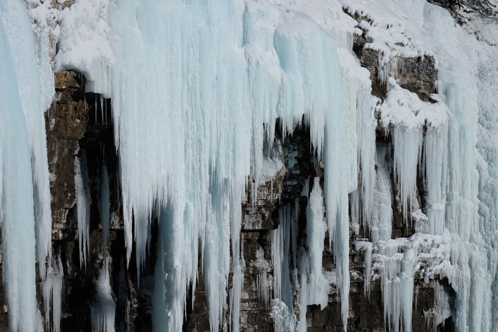
No son muy altas pero sí caudalosas. No sabemos a qué velocidad se congelan pero da la impresión que hasta la espuma y burbujas de aire están heladas alrededor del agua, haciendo que la pared rocosa parezca un bote de espuma de afeitar que se ha roto y ha dejado escapar todo su contenido.


El agua sigue fluyendo por entre el hielo y la roca por lo que cuando estás parado mirando las estalactitas y demás formaciones de hielo se puede escuchar el tronar del agua precipitándose desde lo alto de la pared rocosa. La verdad es que es bastante impresionante.

Caminando un par de km más, esta vez ya subiendo un poco más, en algo más de 45 minutos se llega a las upper falls, mucho más grandes que las lower falls.


Estás cataratas se pueden mirar desde abajo, con el riesgo de que parte del hielo se desprenda y te sepulte (esto se veía venir, y lo vimos, afortunadamente desde lejos) o desde una terraza que han montado en la parte superior.


La excursión al Johnston Canyon es relativamente sencilla, hay algún que otro tramo resbaladizo, y lo suficientemente corta como para no acabar helados con las temperaturas árticas que tenemos por aquí.


Enrique & Marina
English version

JOHNSTON CANYON


Half way between Banff and Lake Louise there’s Johnston Canyon. It’s such a popular walk in the summer that locals don’t even recommend you to go or, if you really want to, be there very early, by sunrise. It’s meant to be really crowded of Chinese, Japanese and tourists from pretty much anywhere in the world. This years it’s going to be particularly busy because the entry fee for all Canadian Natural Parks is free to celebrate the 150th Anniversary of the Canadian Confederation (from the 1st July 1867).


Johnston’s is the classic glacier river canyon with clear waters and a few considerably long water jumps shaped in the middle of a fir three forest. The interesting part of it is that now in the bitter cold of the Rockies’ winter the waterfalls freeze. 


The trailhead is located in the Bow Valley parkway (1A), currently underused because most people choose to take the Trans-Canada highway, just behind the Johnston Canyon Lodge.


The trail is clearly marked and well maintained and you can even find an ice cream shop closed during the winter and an odd shaped three at the very start. There’s no sing with a story about the tree so Enrique had to come up with something. He reckons that the tree didn’t listen to his mum  when a little child-three and used to sit down curving his back. Now the three is a tourist attraction and it’s probably in the family pictures book of many people all around the world.


To get to the first set of waterfalls you have to walk on a well prepared ground and some projected catwalks built over what it’s a creek during the summer and now it’s a mixture of ice, liquid water  and snow with unwary animal footprints. 


The track is mostly flat and the distance to the first falls is only 1,1 km, so basically in about half an hours at the most you’re in the first lot of frozen waterfalls. 


The jump in not very long but the flow looks generous. We have no clue about the freezing speed of the water but the edges around the main frozen river bed look like the bubbles and the foam of a flowing waterfall and the rocky wall on the side looks like covered with rock solid shaving foam. 


Liquid water keeps flowing between the ice and rocks and if you’re quiet while looking at the icicles and the rest of the ice formations you can ear the creek roaring as it drops to the lower level. It’s a pretty impressive view. 

Walking just a couple more km’s, this time a little bit steeper, in less than 45 minutes you reach the upper falls which are way bigger than the lower set. 


There’re two view points to enjoy them. There’s a lookout located on a catwalk at the bottom of the drop and another one a bit further up the track in a balcony built just above the waterfall. The lower viewing platform seems kind of dangerous since the icicles seem that they can become unattached at any time (something that we actually witnessed from the safety of the upper balcony).


Visiting Johnston Canyon should be considered a pretty easy walk even in the winter despite a couple of slippery icy patches. Besides, the time required is short enough to not get very cold even at the under -30 degrees we sometimes reach in the Rockies.  


Enrique & Marina

viernes, 20 de enero de 2017

ESQUÍ DE FONDO

Click here to read the English version


Donde fueres haz lo que vieres, y aquí todo el mundo se mueve patinando. Así que nos alquilamos unos esquís y nos fuimos a probar esto del esquí de fondo.


Estuvimos unas cuatro horas y media marchando arriba y abajo por todos los senderos que estaban ya preparados por el personal del parque. Más tarde hemos descubierto que la mayoría de sesiones de esquí de fondo no suelen pasar de un par de horas como máximo. Para los lugareños salir a esquiar es como en Barcelona salir a correr. A menos que seas un ultramaratoniano (como casi todo el mundo ahora) pues no sales a correr durante casi cinco horas.


Esto del esquí de fondo tiene su gracia y es tremendamente más barato que el esquí tradicional así que este va a ser nuestro deporte de invierno. En parte también por necesitad ya que hay tanta nieve que es imposible ir de excursión sin esquíes o raquetas de nieve.


Nuestra técnica debe hacer daño a la vista pero nos movemos, que en el fondo es lo que cuenta. Y parece un deporte muy completo ya que acabas con los brazos más cansados que las piernas, que afortunadamente no sufren ningún impacto (al contrario que cuando corres). Es un poco como ir en bicicleta pero sin bicicleta. 


Empezamos por uno de los senderos o carriles o como sea que se llamen que está justo detrás de casa y que sigue el curso del Bow River por dentro del cámping de Lake Louise, actualmente cerrado ya que no pueden conectar el cercado electrificado y todavía hay un oso pardo que no ha ido a hibernar.


Una vez tuvimos ya cierta confianza y dejamos de parecer Michael Jackson haciendo el moonwalk nos aventuramos hacia el otro extremo del pueblo, donde cogimos el sendero llamado Tramline que sube hasta The Divide, donde seguimos por la carretera que lleva hasta el Moraine Lake.


Después de unos kilometrillos de subida nos avisaron de que la carretera estaba cerrada antes de llegar al famoso Moraine Lake por el riesgo de avalanchas así que nos dimos la vuelta. Y qué divertido. Pones los esquíes en los carrilitos y bajas como si fueses un coche de Scalextric, y menos mal porque ya íbamos bastante cansados.

Marina encontró en el trastero de casa unos esquíes y unos botines de su talla así que ahora sólo tenemos que alquilar los míos, menudo chollo.


Enrique & Marina
English version

CROSS COUNTRY SKIING


In Rome do as the Romans do, right? And here in the Rockies everyone gets on the move sliding in some way. OK, so let’s do the same. We got ourselves some cross country skis and off we go.


We spent about four hours going up and down exploring the tracks nearby our house that were mostly already track-set. We latter found out that you normally don’t ski for such a long time unless you’re going somewhere. The usual length of a skiing session is about a couple of hours or so. Cros country is the pretty much the winter equivalent to running in Barcelona so, unless you are a ultra-marathon runner (well, like almost every second person now…), you don’t go out running for nearly five hours on a regular basis. 


It turns out that cross country skiing is quite a lot of fun and considerably cheaper than down-hill skiing. For this reason, we’ve decided that it’s going to be our winter sport while in the Rockies. Well, for this and also because there’s so much snow on most of the tracks that exploring the mountains is literally impossible unless you’re using skis or snow shoes. 


We’re still working on our technique. So far we manage to slide down and climb little hills without losing our dignity. Eventually we’ll look stylish. Besides, it apparently is a very complete sport because you not only use your legs but also your arms and, since you’re sliding, knees stay free from any impact (as opposed to running).


We started easy at the back of our house in the Bow River track and the camping ground loop.  Note that the camping is closed for the season and also because the electric fence that keeps wildlife away doesn’t work in the winter… At that time there was a bear still not hibernating and we had to keep our hears open for any dangers. The access to this area is now closed to the public because it’s too close to a river that recently got flooded with icy water and a huge ice block current. The damage was pretty scary and Parks Canada has decided to close the access to all the tracks surrounding the Bow River within Lake Louise Village. 


After getting some confidence and when we didn’t completely look like Michael Jackson dancing the moonwalk, we crossed up to the end of the township to take the Tramline track that leads up to The Divide, where we took Morraine Lake Road for a short bit. 


After skiing up for a few minutes we were warned that the end of the road was closed due to avalanche danger and that we were not going to make it to the lake itself. Again we decided to turn back. It was getting too late anyway and we aren’t very experienced in this environment yet. Oh! and going down was a lot of fun! You place your skis in the little tracks set in the snow and you basically can just let yourself go like a Scalextric car! So sliding down is faster and way less tiring!

I was lucky enough to find a set of skis left behind at our place that fit me pretty well. They’re really old but they work well if I wax them properly. So basically I can now go skiing instead of running anytime and when we go on an adventure it’s only one set to rent. What a bargain, hey? 

Enrique & Marina

jueves, 12 de enero de 2017

EXCURSIÓN HASTA EL LAKE AGNES

Click here to read the English version


Al no tener coche vamos caminando a todos lados, así que las excursiones que vamos haciendo, al menos de momento, empiezan todas por la ascensión hasta Lake Louise. Una vez ahí hay multitud de senderos para escoger, así que nosotros decidimos subir hasta el Lake Agnes.


El camino sale casi desde la recepción del Chateau Lake Louise y asciende a través del interminable bosque de abetos en dirección a dos picos: el Big Beehive y el Little Beehive (la Gran Colmena y la Pequeña Colmena, parece que los bautizase Camilo José Cela).


A medio camino se pasa por el Mirror Lake, que traducido al castellano es Lago Espejo. Esto debe aplicar al verano porque ahora está completamente congelado por lo que no refleja nada. Se le ve potencial por eso, ya que está muy resguardado del viento, así que habrá que volver cuando no esté helado.


Pasado el Mirror Lake se sigue hacia la casa de té más alta de Canadá, justo situada a orillas del Lake Agnes. En invierno está cerrada ya que se encuentra en zona de avalanchas y, no nos engañemos tampoco, a ver quién es el guapo que sube las provisiones con toda la nieve y hielo del camino.


Desde el Lake Agnes hay unas vistas muy bonitas del valle donde se pueden ver ambos Lake Louise, el lago y el pueblo, con la estación de esquí al fondo.


Desde el Lake Agnes seguimos caminando hacia la Little Beehive pero empezó a nevar y estábamos en una zona de avalanchas realmente clara así que nos dimos la vuelta. Al final resultó ser la decisión correcta porque tardamos más de lo que pensábamos en llegar al pueblo y casi se nos pasa la hora de cenar, que aquí son las 16:30.


Enrique & Marina
English version

HIKE UP TO LAKE AGNES


We don’t have a car yet and we have to walk everywhere and this includes all the trailheads. Pretty much every track close by starts at the Lake so we always have to hike up to start. 


The track starts pretty much behind the Chateau Lake Louise and climbs through the thick pine forest towards two peaks called Big Beehive and Little Beehive. 


Half way we past Mirror Lake. That must be because of the reflection you get in the summer because right now it’s completely frozen an covered in snow and nothing shines back. It looks like it’s got great potential, though. It’s pretty sheltered from any possible wind which is super important. We’ll come back in the summer and tell you. 


A little higher than the Mirror Lake there’s the highest teahouse set in Canada, on Lake Agnes’ shores. The establishment is closed for the season because it’s located within avalanche risk area and, honestly, because taking supplies up there with all the snow and ice on the way must be too hard for the revenue they’d get from the few coffees they’d sell throughout the day. 


From the lookout at Lake Agnes the views overlook Lake Louise Village at the bottom, Lake in the middle and Ski resort at the end. 


We followed the path leading to Little Beehive for a bit but it was snowing and the snow looked really thick and really fresh. It looked like no one had been walking those ways lately and therefore we decided it might be too risky to go ahead, so we turned around instead. Also it was dinner time was getting close and we still had to go back to the Village, where dinner starts at 16.30 for us. 

Enrique & Marina